Chapter 1 (Locating Places on the Earth) Class-6 Social Science Question Answers
Topicwise Question Answers
In this chapter we will learn about Earth, Map, directions of map and componets etc.
Q9.. What is a map and how do we use it?
Answer: A map is a representation, or a drawing, of some area.
a). It may be a small area (a village, a town, etc.).
b). It may be a bigger area (say, your district or state).
c). It may be a very large area like India or even the whole world.
Q10. What are the main components of the map?
Answer: There are three components of the Maps:
a) Distance b) Direction c) Symbols
Maps are drawings, which reduce the entire world or a part of it to fit on a sheet of paper.
Q11. What is the meaning of the blue coloured areas?
Answer: The blue coloured areas indicates the Water from ocean and seas.
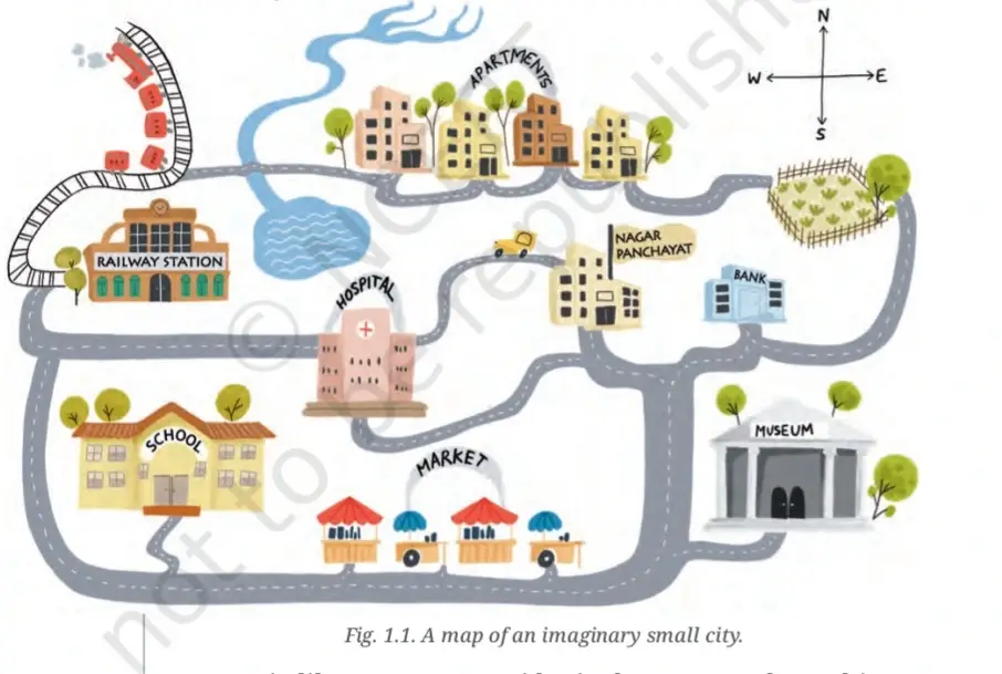
Q12. See the picture carefully and answer the following question:

Which is farther away from the railway station —the school, the Nagar Panchayat or the public garden?
Answer: The Nagar Panchayat is farther away from the railway station.
Q13. What is an atlas?
Answer: An atlas is a book or collection of maps.
Q14. What are the types of maps?
Answer: There are several types of maps:
i) Physical Maps: which mainly show some natural features such as mountains, oceans and rivers (see an example in Fig. 5.2 in this textbook)
ii) Political Maps: which show details of countries or states, boundaries, cities, etc. (for instance, a map of India with all its States, Union Territories and their capitals).
iii) Thematic Maps: With a specific kind of information (examples include Fig. 6.3 and Fig. 8.1 in this textbook).
Q15. What are Cardinal directions?
Answer: Cardinal directions are the main or primary four directions of the compass. They include North, South, East and West.
Q16. What are intermediate directions?
Answer: Cardinal directions are the primary directions of the compass are known as the Cardinal directions, while, the points in between the cardinal directions are known as the intermediate directions.These are Northeast, Northwest, Southeast and Southwest.
****************************************************
To Learn More Click Below:
Timeline and Sources of History
*********************************************